Six years ago, Paul and I went to the Grand Canyon. It was our honeymoon, and only our second time backpacking together. We had many lessons to learn. Our packs were too heavy, Paul got heat exhaustion, and it took us until after dark to hike 13 miles. I was so sore the next day I could barely walk. Still, we learned our lessons, lightened our loads, and continued on to Canyonlands for more backpacking adventures. It was there that we decided we wanted to hike the Appalachian Trail, and the rest is history.
We’ve been back a couple times since then. It’s a lot easier than it used to be. But the canyon never gets old. Each trip into the abyss leaves me wanting more. Hiking rim-to-rim has been on my bucket list since the first time I visited the canyon. Back then it seemed far-fetched, but these days it’s comfortably within our capabilities.

Usually, people do a rim-to-rim in one direction, sometimes over several days, and take a shuttle between the north and south rims. It takes a lot of time and planning, because to drive from one rim to the other, you have to drive completely around the canyon. Also, while the South Rim is open year-round, the North Rim doesn’t open until mid-May. Therefore, we knew we’d that if we wanted to do this hike in early May, we’d have to make it a rim-to-rim-to-rim, starting and ending at the South Rim.
We decided we’d do this over 2 days, hiking from the south to the north on day one and camping at the North Rim, then returning to the South Rim on day 2. This allowed us to avoid trying to get a campsite below the canyon rim, which is pretty unlikely if you haven’t planned quite a bit ahead. When the North Rim isn’t open, the only way to get there is by hiking there, and not very many people do that, so it was easy to get a walk-up permit to camp on the North Rim. The only preparation we had to do ahead of time was reserve our campsite at the South Rim.

Generally speaking, hiking rim to rim in a day is not recommended. It’s a strenuous 22 miles. The South Kaibab Trail lacks shade and water. Temperatures can fluctuate over 70 degrees between the high at the bottom of the canyon and the low at the top. Many people underestimate the strenuousness of a 5,000+ foot climb and the effects of hiking in the heat. Fortunately, Paul and I were well aware of what we were getting into. So, despite the Park Ranger’s skepticism, we were confident we’d be comfortable on this hike, although maybe a little sore after.
Day 1
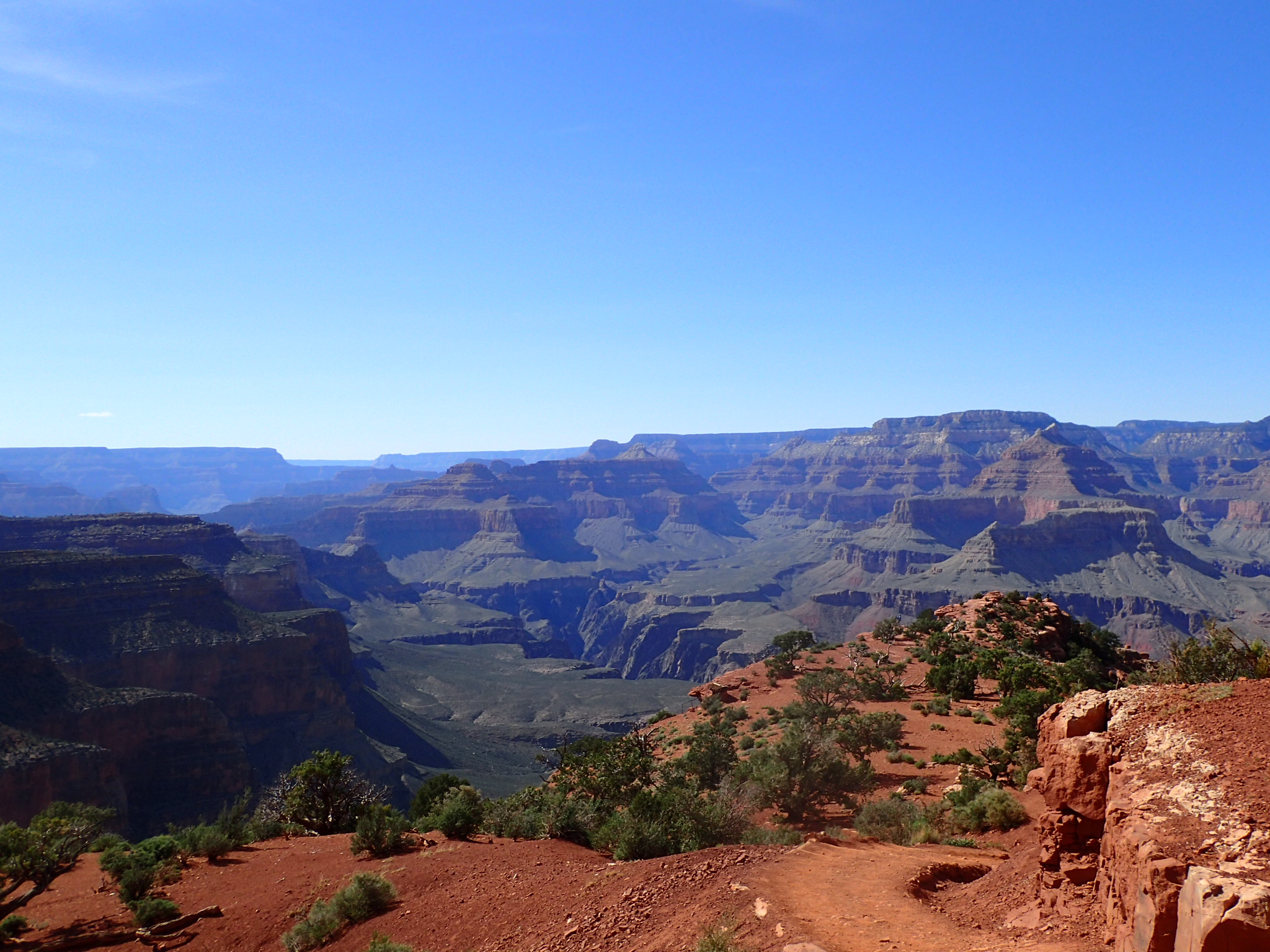
We woke up before dawn, ate breakfast and packed up our campsite before driving to the backcountry lot. There we parked the car and caught the shuttle to the trailhead. We wanted to be hiking early to beat the heat, but didn’t feel the need to hike before it was light out. So, we took our time and didn’t rush to get on the very first bus. The ride to the trailhead took a little longer than we anticipated, but we were on the South Kaibab Trail shortly after 6:00 am. It was breezy and a little chilly as we started our descent. Feeling fresh, we kept a fast pace as we descended. The sky was slightly cloudy, adding to the shadows and streaks of light that play off the rocks of the canyon walls. We made our way past groups of tourists clogging the trails to take photos, and before long the crowds were behind us, and only other hikers were around.

After about 4.5 miles we took a short break at the tip-off, where the South Kaibab Trail intersects with the Tonto Trail as it meanders across the Tonto Plateau. I’ve only been a short distance down the Tonto Trail, but one day I’ll be back to do more. After the tip-off, the trail offers us our first glimpse of the river at the bottom. The rocks in the section are dark pink and red, a dramatic backdrop to the green plants and grasses.
Before long we started to see groups of trekkers making their way up and out of the canyon. We caught our first glimpse of the cable bridge that spans across the mighty Colorado River. I spotted a hiker heading up the trail that looked like a thru-hiker: small pack, running shoes, ultralight gaiters. As he approached, we recognized each other – he hiked the PCT the same year we did. We caught up for a few minutes before heading on our way.

Still feeling good and wanting to continue on before it got too hot out, we crossed the river and hiked past Phantom Ranch and Bright Angel Campground without stopping, continuing on the North Kaibab Trail. In the late morning, this segment of trail was completely empty. The trail meandered up a narrow side canyon carved out by Bright Angel Creek, and we stopped in the shade of the canyon walls to enjoy the solitude and take off our shoes for a few minutes.
As the canyon started to open up and the sun made its way higher in the sky, the shade ran out and we were in the full sun. Fortunately, the trail is pretty easy between Bright Angel and Cottonwood campgrounds: it climbs only 2,000 feet over 7 miles. We made it to Cottonwood campground shortly after noon. We ate lunch on a picnic table in the shade of a Cottonwood tree, enjoying the rest and the shade.
After Cottonwood, the trail really started to climb, gaining 4,000 feet in the 7 miles between Cottonwood and the North Rim. The scenery remained dramatic and beautiful as we climbed. The north side of the canyon has much more vegetation and greenery than the South side, and we enjoyed the views the entire way.

We passed a few cyclists who were cycling the Arizona Trail. Because biking isn’t permitted in the canyon, thru-bikers have to carry their bikes across on foot. Considering their bikes alone weigh more than our entire packs, they were looking a little tired. As we neared the North Rim, we passed several trail crews working to get the trail ready before the North Rim opens in a few weeks. We thanked them for their labors as we passed, eager to reach the top. Since the North Rim is higher and wetter than the South Rim, the trail at the top walks among pine and Douglas-fir trees, offering intermittent glimpses across the canyon. We reached the top a little after 4:00 pm, and followed the road to the campground.

There were a few workers at the North Rim, but other than that, we had the place to ourselves! We set up our tent right along the rim, ate dinner and enjoyed the views across the canyon. Above the South Rim, we could even see the snow-capped San Francisco Peaks near Flagstaff. We were both pretty tired by the end of the day, so we went to bed early and slept cozily in our quilt in the chilly night.
Day 2
We woke up at dawn, packed up, and headed back to the trail. We were hiking by about 6:30 am, and saw more hikers coming up the trail than we expected on the way down. Throughout the day we saw many thru-hikers and stopped to chat with several of them.
We made it to the bottom of the canyon by lunchtime, and we stopped at Phantom Ranch for some ice-cold lemonade. We took a long rest in the shade, debating which trail we should take back to the South Rim. The South Kaibab Trail is 7 miles long but has no water, little shade, and climbs 400 feet higher than the Bright Angel Trail. The Bright Angel Trail has water and more shade, but it’s 9.5 miles long and more crowded. The Kaibab Trail won out. We’ve been up the Bright Angel Trail several times, so it’s time to go up a different way.

The bottom half of the South Kaibab Trail is a nicer climb than the top half. Maybe it’s the dramatic red rocks and stellar views, but I think it’s a more evenly graded trail and more shade from the canyon walls. The upper half is more like a giant staircase. Each step is a big step up, and it gets both mentally and physically tiring. In the heat of the afternoon, Paul started to get grumpy on the staircase. However, he was determined to complete the trail in the same time frame as the day before, which meant getting to the rim by 4:30, so stubbornness pushed him on.
As we neared the rim, things got crowded and the breeze returned, giving us extra motivation to get to the top. We made it out by our goal. It took us ten hours each way. We took the shuttle back to the lodge for a hot meal before heading back to the campground for the night. I expected to be more sore than I was, but I definitely felt it on the way home the next day. Unfortunately, I did get 2 blisters on my left foot but neither of them was painful. My feet aren’t as tough as they used to be! Next time we come to the canyon, we’ll explore some of the lesser-used trails.
Great photos! Did South Kaibab up & down with (2) nights at Phantom Ranch years ago (You guys were probably still in diapers!…that long ago). Your trip makes me want to go back.
What did you use for a camera on this trip?
Thanks! Still using the Olympus TG-4, but we’re ready for an upgrade, it’s getting a little slow.
We had no doubt you’d meet your goal ! So proud of y’all 👣👣
I just recently ran the North to South in May this year, with a plan of returning South to North the next morning. Unfortunately, I didn’t have what I needed for this trip, even though it was well planned, because Mother Nature decided to give us snow and 25F at the North Rim, hail, sleet, and rain mixed with a little sunshine in the valley. I ended up struggling with a bit of hypothermia, crazy right? It does make me want to go back and finish my dream of doing a R2R2R. Like you said, it never gets old.
Appreciating the time and effort you put into your website and in depth information you offer. Sounds like it was quite the adventure! Say you just wanted to hike down, then up one side in a day or over a couple of days – with kids. Which side would you recommend as being more ‘kid-friendly’? Thanks!
The South Rim is better: it is a shorter trail with less climbing. The Bright Angel Trail also has more water and shade than the Kaibab Trail, which has none.