Sometimes, things don’t work out according to plan, and you have to adjust. Then things don’t go to the new plan, so you adjust again. This is how we ended up hiking the Rae Lakes Loop. We had much grander plans, but road closures, schedule constraints, and altitude sickness threw lots of wrenches into those plans, so the Rae Lakes Loop was what we could salvage out of our trip. But referring to it that way doesn’t really do it justice. The Rae Lakes Loop is a spectacular little loop in the High Sierra, including segments of the PCT and JMT and several scenic high mountain passes, not to mention some memorable high altitude lakes.

There were three of us along on this trip: me, Paul, and my coworker and fellow long distance hiker Bill. We camped overnight at the Onion Valley campground, near Independence, California. We were accessing the Rae Lakes Loop from the eastern side, meaning we first had to climb over Kearsarge Pass (11,709 feet or 3,568 meters) to join the route. We’ve been over Kearsarge twice before, as part of our PCT thru-hike back in 2017. It’s a beautiful pass and carries strong memories for Paul and me. This is where we decided to skip ahead and avoid the treacherous conditions resulting from the record snowpack of 2017. It was a hard decision and put a damper on our hike for a while after, making a bittersweet memory. But, we ultimately returned to the section of the Sierra we skipped around a couple months later, and hiked south to officially complete our PCT thru-hike at Kearsarge, and what a great memory we have of that day!

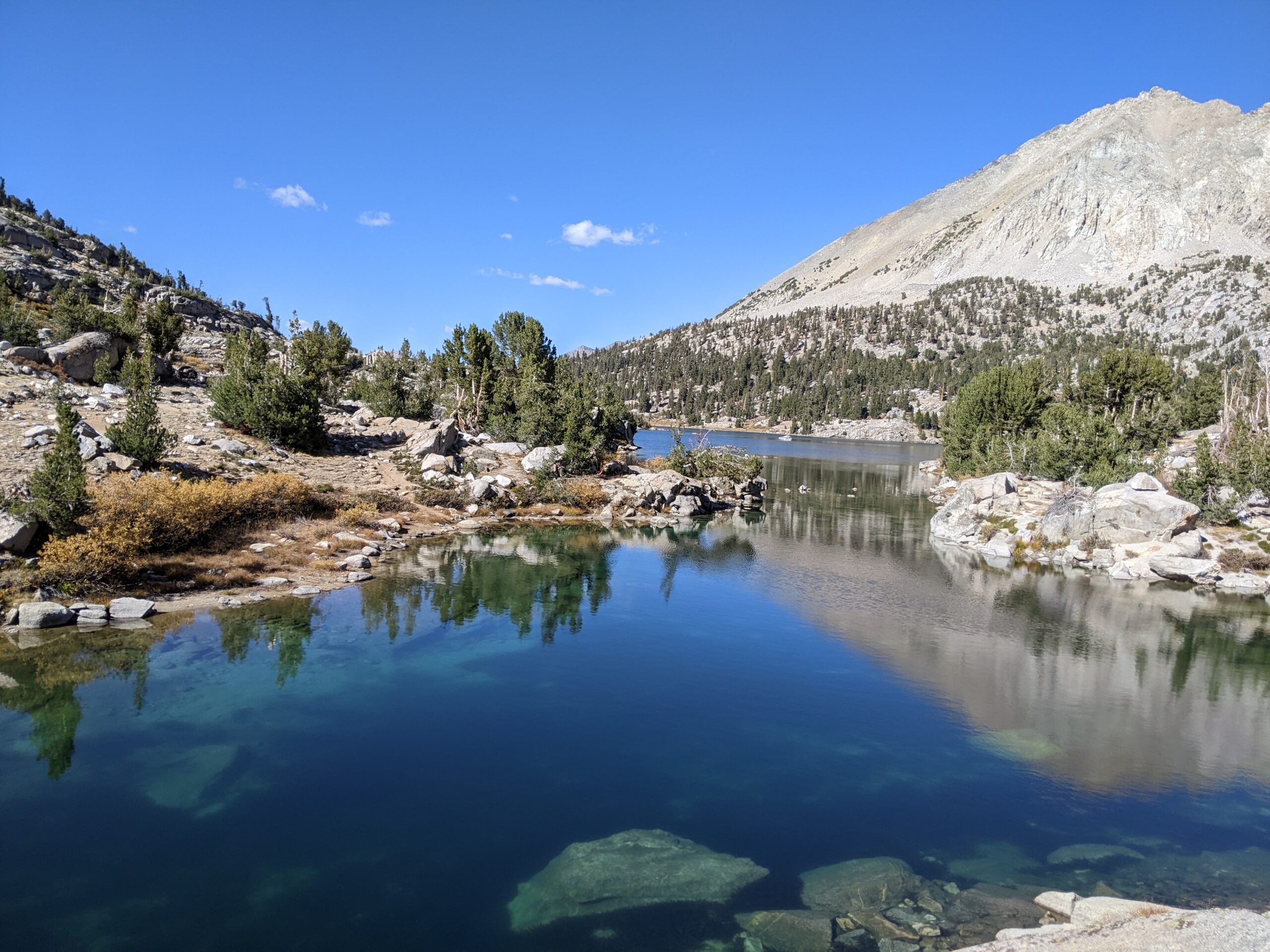
We rose early in the morning, packed up and moved the car over to the trailhead lot, leaving all our scented items in the provided bear lockers before we officially hit the trail. The climb up to Kearsarge passes by several scenic lakes and we reminisced as we climbed. Here where the trail was an ankle deep stream, rushing from the excessive snowmelt. Here where Paul slipped and postholed and we decided we were over the terrible conditions. Here where we camped for the night before heading down to Independence to explore our options moving forward. Here where we glissaded down a steep ravine rather than continue hiking across miles of snowpack and I tore a hole in my pack. We crested the pass and took a break at the top, enjoying the view of the stunning peaks in front of us and the lakes below us on both sides. Behind us, we could see all the way to the desert floor and across the valley to the White Mountains rising from the east. Ahead of us, the snow-capped jagged peaks of the Sierra and high alpine lakes awaited.

We descended to Bullfrog Lakes, again reminiscing about hiking across this snowy valley, the lake still frozen, and climbing straight up the snow on the side of the mountain to join the trail over the pass. Conditions are decidedly more pleasant when the ground is dry and the sky is blue and the air is cool and crisp with fall. Soon enough we were on the PCT/JMT, and we turned right to head north. Last time Paul and I came this way we were headed south, so we got to enjoy a different perspective this time. Last time Bill came through here was in early season 2018. While it was not as treacherous as the snowpack of 2017, he nevertheless came through early enough that the snow covered the trail, so in a sense he was experiencing this area anew as well.

Hiking in the High Sierra is tiresome, even on trail. The routes climb seemingly endlessly to cross high mountain passes, only to descend thousands of feet to the valley, before crossing a river or stream and heading right back up over the next pass. Despite the hard work, the changing scenery is stunning. At lower elevations, the trail travels under the cover of trees, including sequoias and bristlecone pines. Eventually the trail climbs above the treeline, and the terrain becomes rocky and steep. From up high, the views are expansive. If you know what you are looking for, you can spot the pass you last crossed, and probably the next one you will cross. Above the treeline, you’ll cross high meadows dotted with clear blue lakes against a backdrop of jagged snowy peaks. Eventually, you’ll climb again, not over the peaks but through the depressions between them, where intrepid humans of the past discovered passable routes and sometimes even blasted pack trails out of the rock with dynamite. Tiring though it is, my mind always wanders to the namesake of this trail we follow. John Muir would travel up to 40 miles in a day, often traveling in a suit and carrying little more than a loaf of bread. There were no dynamite blasted trails for him to follow – the man was merely exploring this serene and harsh land for his own enjoyment and curiosity.
Our second pass of the day would be Glenn Pass (10,449 feet or 3,214 meters), one that stands out in my mind as particularly rocky but especially scenic, just above the impressive Rae Lakes. The final rocky switchbacks to the top seemed to go one forever, and we started to spread out as we each made the climb at our own pace. Bill reached the top first, me second, then Paul. At the top, we stopped for a rest and chatted with a senior hiker carrying a very large backpack. He explained that he had 3 (three!) full bear canisters in his pack. An old-school hiker, this man has traveled some of the off-trail high routes that we were hoping to get a taste of on this trip. It is always refreshing to see older hikers out in the rough, still doing hard things. Given the weight on his pack, he certainly had a harder hike on his hands than we did. But he also had a knowledge of the area far beyond ours. It was the knowledge of time and experience, and we thoroughly enjoyed talking with him.

By this point, my head was throbbing, a symptom of the altitude. Normally I do not have too much trouble with altitude sickness, especially not at elevations only in the 10-11,00 foot range, but living at 2,300 feet means that I’m not acclimated to elevation. The rest of the day would be descending, so I popped an ibuprofen, drank some water, and didn’t think too much about it. I think I was feeling the worst of the three of us, but everyone was having at least some mild symptoms. We continued down to the lakes, filtered water and took a break, hoping to feel better with some rest, water and food.

As the day wore on, we continued dropping in elevation, but I continued to feel worse. Most of the time the trail was descending, but every once in a while there would be a small climb. Even if it was only 5 steps of climbing, I would find myself winded and exhausted. This was frustrating and slightly concerning. I was moving much slower than usual. All we could do was continue to descend, so on we pushed, me lagging behind the other two as the afternoon turned to evening. We passed a few thru-hikers heading southbound on the JMT and the PCT. Though we were not on a thru-hike, our gear gives us away as thru-hikers, so most of the hikers stopped to ask about our hike, and we asked about theirs, exchanging pleasantries and offering encouragement to the hikers, who by now were mere days away from leaving the mountains behind and crossing into the desert. In total we passed more than 15 thru-hikers before the day was done.

We finally made it to Woods Creek, at about 8,500 feet (2,590 meters). I had intended we would travel farther this day, but my slow pace in the afternoon made that unlikely. There was a nice campsite with a bear locker near the creek and the sun was getting low in the sky, so we decided to stop for the night. A group of thru-hikers came through and camped nearby as well. I hoped that a night at slightly lower elevation would make me feel better.

We again rose early and departed the PCT/JMT to follow the Woods Creek trail to the west, as it continued to descend, past Paradise Valley where we had hoped to camp the night before, and on to Bubbs Creek. We descended all the way down to 5,200 feet (1,584 meters) before the trail turned and immediately started climbing again. I felt better as we descended, and we all enjoyed the changing of scenery as we dropped in elevation. Both Paul and Bill ended up declaring this segment their favorite of the route. We also found more solitude in this segment. Being off the busy JMT/PCT corridor meant that we went most of the morning without seeing other hikers and we enjoyed the quietness of this stretch of trail.

Upon reaching Bubbs Creek, the trail began to climb steeply – I think I counted 19 switchbacks over the next mile as we seemed to climb straight up. Soon we came to a decision. The initial plan was to follow the Avalanche Pass Trail to the south and join an off-trail high route for a stretch before returning to the PCT. However, given the experience I had the day before, climbing a much more strenuous route at elevation up to 13,000 feet (3,962 meters) did not feel like a wise idea. I still felt sluggish during the climbs. We decided to continue on the Bubbs Creek trail instead, a decision that proved wise. My symptoms returned as we climbed, and again I felt like I was moving in slow motion. When we arrived at camp for the night I had little appetite and laid in bed for a long while before feeling well enough to eat dinner. I fell asleep early, hoping the rest would be helpful.

By morning, I was feeling a little better. We still had options to extend the hike, but even simply taking the long way back to the PCT would mean climbing over Forester Pass (13,153 feet, or 4,009 meters). Again, climbing to such high elevations felt foolish considering the circumstances, so we all decided we would stick to the Rae Lakes loop and finish the hike earlier than planned. We would use the extra time to drive to the White Mountains and explore the Ancient Bristlecone Pine forest. But for now, we still had hiking to do, and I was actually feeling pretty good. As we climbed, I noticed I was hiking faster than Paul, something that usually happens but had not the day before, so I took this as a positive indication that I was improving. The weather was cool but clear and beautiful and we stopped often to take in the views.

Before we knew it we were back on the PCT, now south of the point where we first joined the trail heading north, so we again headed north to meet back up with the junction to Kearsarge Pass. This final section seemed like an endless climb. The trail switched back and forth through the trees, eventually reaching high enough to offer views south to Forester Pass, the highest pass of the PCT/JMT, that we would have gone over if we had not modified the route. No matter, we were all thoroughly enjoying this day and the lovely scenery. When we arrived at the junction we took a break before continuing on the final leg of the journey.

There are 2 routes to Kearsarge Pass from the PCT – one lower, one higher. When we hiked in a few days prior, we came down along the high route. Returning now, we would follow the low route. Calling one high and one low is an unofficial description. Each of these trails has its own name, but the description fits. One route stays higher as in contours down the side of the mountains, the other stays in the valley, following the lakes before finally making a steep climb to join the high route and make the final ascent to the pass. Like most of the high passes in the Sierra, Kearsarge is rocky and rugged. Approaching, it can be difficult to make out where exactly the pass will crest the ridgeline, everything looks too rugged until all of a sudden, there you are. Because this is my third time crossing the pass from this side, I am well aware of where we are headed, but I enjoy the dramatic features of this pass as much as any along the official PCT.

At last we reach the pass, and it’s all downhill from here. Although it feels close, we have a long way to go back to Onion Valley. Bill started to jog and was soon out of sight. Paul and I followed suit but eventually slowed down and took in the views. Some twists and turns later, and we were on the final stretch. The parking lot came into view and again we jogged, eager to get back to the trailhead.
Once back, we drove down to Independence and headed north on 395 toward Big Pine. We stopped for pizza before heading up into the White Mountains. We camped at a campground near the Ancient Bristlecone forest and hiked around in the awesome bristlecone forest. From the trails in the White Mountains, walking among some of the oldest organisms on the planet, we could see the Sierra range to the west, and Death Valley to the east. Now it was Bill’s turn to feel the effects of the altitude, and his pace started to slow. Fortunately, we were free of our backpacking loads and in no rush, so we took it slow and enjoyed the pines.

If we learned anything on this trip, it’s that altitude sickness can hit unexpectedly. I’ve never struggled acclimating to altitude before, and I assumed that camping at relatively high elevation the night before would be sufficient. In the end, all of us felt the effects at some point or another, despite the fact that all of us have done just fine at much higher elevations. It was a good reminder of the need to be flexible and make adjustments as needed when you are out in the backcountry and things don’t go to plan. In the end, we all agreed it was an enjoyable trip and the scenery was spectacular, even if it was not exactly the hike we set out to do initially.