If you’ve followed my blog then you know I am a little obsessed with Arizona’s Sky Islands, the archipelago of pine and oak covered mountains scattered across southwest Arizona, separated by a sea of desert. So when Paul and I first started getting interested in bikepacking, this may be the first route that caught our eye. There are actually a variety of different loops that make up the Sky Islands Odyssey, and naturally, we started with the one ranked the most difficult. Maybe because we know people who have done this route, maybe because we just love to suffer. But we knew the scenery on this one would be fantastic.
Five mountain ranges surround Tucson, four of which qualify as sky islands. The Santa Ritas, a distinctive part of the skyline to the south of Tucson, are one of the most accessible as well as the highest, rising over 9,000 feet above sea level. Fortunately, this bike route would only take us up to about 5500 feet, enough to experience the changing biomes and the incredible diversity of species that make up southeastern Arizona.

My coworker Bill joined us on this trip at the last minute, after bailing on a backpacking trip but still having some time off before going back to work. This would be his first bikepacking trip, but as a fellow thru-hiker we knew he could suffer well and would be up to the challenge. We started in the little town of Patagonia, riding out of town on pavement before quickly turning onto dirt track. The beginning of the route was beautiful. The road was wide and smooth and shady, we followed a stream for a long while and encountered a handful of riders out enjoying their weekend.
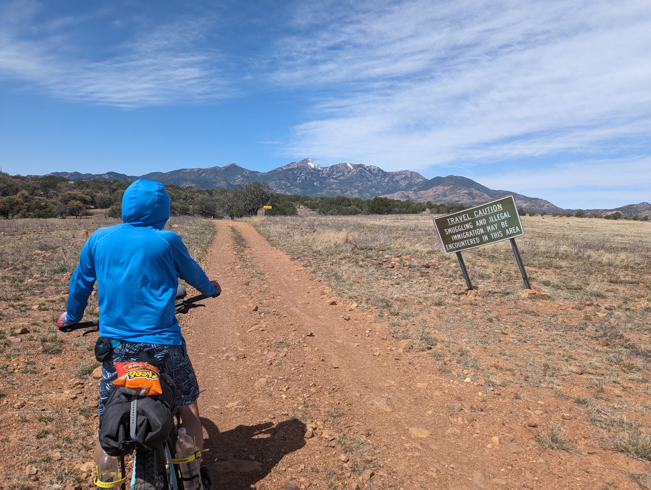
As we left the stream behind and the landscape became more grassy, we spotted plenty of wildlife: a pronghorn and quite a lot of birds, including the flashy vermilion flycatcher and western meadowlark. Not to mention cows. And the Border Patrol. This is Arizona after all. The terrain was hilly, moving gradually uphill to Canelo Pass. Because camping is limited along certain portions of this route, we initially planned to camp shortly after going over Canelo Pass. But we got there quite early, and decided that pushing ten more miles to the next area we could camp would be relatively downhill and easy.

The terrain was fairly easy for the entire first day. Our last mile or so of the day we turned onto a very chunky road and seeing the terrain was about to get difficult, we found a campsite and called it a day, after 32 miles of beautiful riding. It was a bit chilly in the night and I heard a few coyotes, but overall everyone slept very well.
Our morning on day 2 was indeed some challenging terrain, but the rollercoaster-like ups and downs made it pretty fun. Soon enough we turned onto a road with a smoother surface and eventually pavement as we neared the town of Sonoita. We had failed to consider that practically everything in this small town is closed on Monday and Tuesday, but the local ice cream shop was open and happened to also serve coffee and breakfast burritos, so we enjoyed a hot breakfast before hitting up the market and continuing on our way.

Leaving Sonoita, the route started to get a little chunky again, though instead of a roller coaster we were now mostly just slowly climbing. We saw a lot more cows and a few horses. We turned onto a primitive road and stopped for a long break to observe the solar eclipse. We brought our eclipse glasses along for the journey, and enjoyed the show for well over an hour before we picked up and carried on. (During the previous North American eclipse in 2017, Paul and I were also on trail, hiking the PCT in Washington. This is a good tradition.)

We traveled on rugged roads and even a small slice of singletrack before we made it to Kentucky Camp, an old mining outpost along the Arizona Trail. We took advantage of the picnic tables, bathrooms and water spigot before continuing our climb. The afternoon was warm and the climbing was slow and steady, until at last we reached the top and began a very long, very cool descent. The road wound down along the side of a canyon, offering some incredible scenery and very easy riding. This section was probably the highlight of the trip for me.

Near box canyon, the road level out some and we entered the Santa Rita experimental range. We crossed a gate and started down a sandy road, still heading mostly downhill, now in more open terrain with wonderful views of Mount Wrightson and Florida Saddle. We found a nice flat spot to camp after 42 miles of rising, and our friend Randy drove out to meet us and camp for the night before he headed to Patagonia Lake to fish the next day. It sprinkled in the night, but not enough to get wet. I heard more coyotes, but they were farther away than the cows, who also made their share of noise.

The night was warmer than the previous night, but somehow the morning seemed chillier. Maybe it was because most of the morning we were headed downhill, toward Green Valley. We stopped at Safeway and had breakfast at a cafe before riding out of town and joining the Anza Trail. I personally know more about the contemporary Escalante expedition (both expeditions took place 1775-1776) but I do know that this particular group was special in that it included more than 100 children, and unlike Escalante’s mission, the Anza expedition was a success, eventually making it to and founding San Francisco. The Anza trail was wide and flat and the riding was lovely, but before long, we were climbing the paved road to Mount Hopkins and then turning onto the roughest road of the trip.

We were forewarned that there would be 12 miles of morale-crushing terrain, and we proceeded with cautious optimism. We were making better progress than initially planned and had hopes to finish the route by the end of the day. The initial plan was to camp about 14 miles before Patagonia, but we had made better progress than anticipated the last 2 days. After the first 4 miles on this chunky road, we were starting to wonder what the big deal was. Sure, the riding was slower given the terrain, but we were still making good progress. We were starting to think the warning might have been overblown. How naive of us.

Over the course of the next 8 miles, we changed our minds. The road got more and more rugged, and steeper. There would be rough sections with loose rocks and grades over 10%. We frequently had to dismount and push the bikes up exhausting climbs, exposed to the afternoon sun and no options to stop until the climb was done. The views were stunning but the road just kept climbing. We saw 3 vehicles over the course of several hours: Border Patrol, a Jeep, and an OHV. Everyone but the Border Patrol stopped to say hello, probably mostly because they thought we were nuts.

At last we reached the end of the climb, pretty thoroughly exhausted. We stopped at the adobe ruins we originally planned to camp at around 4pm. With only 14 miles left, mostly downhill, we decided to push on. Although there were some very small uphill sections along the way, it was mostly downhill, so we covered miles much faster than we had on the climb. In fact, the rugged 13-mile climb took us nearly five hours, while the final 14-mile stretch took about two hours. The final miles were flat and smooth as we finally approached Patagonia, tired after a day of riding over 50 miles including some truly challenging terrain. But what a rewarding day it was. Although that stretch was rough, it was also absolutely stunning and will remain the most memorable segment of the route for sure.

Back in Patagonia, it was still Tuesday so like Sonoita most everything was closed. We stopped at the market for some sodas before heading home. We all ended the day exhausted but satisfied, and looking forward to biking the west loop next.