The natural history of all the mountains in the Sonoran Desert are intriguing, but perhaps none have a richer human history than the Chiricahuas. Named for the Chiricahua band of Apache who lived here, the Chiricahuas and the neighboring Dragoon mountains are where the Apache made their last stand resisting the encroaching white settlers intent on confining them to a reservation.

Mangas Coloradas, Cochise, and Geronimo are just a few of the leaders who traversed these mountains. Though not all Chiricahua Apache, they are all Central Apache – members of various closely related bands of Apache who became the last group of natives holding out against the U.S. government’s campaign to subdue and confine them. I wonder what the trails in this range looked like in those days, before they were further built up and then ravaged by modern fires and floods. Nowadays, the trails are fairly overgrown. Some of them are difficult to follow, some are gone altogether. I wonder what the range looked like in the days of Cochise, and I marvel at the ruggedness of the terrain that helped the Apache evade their enemies for some time.

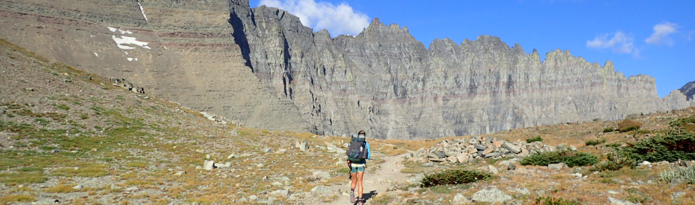
Today, this range is the eastern terminus of the Sky Islands Traverse. We started the SkIT by climbing up to Silver Peak. It was a hot day and the trail did not have a lot of shade, but we’ve gotten used to the challenges of hiking in the heat. Not far in though, we came across some hikers who were not. Stopping to rest in the shade of a tree, the two hikers looked worn out and hot. We asked if they were ok, they said yes but admitted they were out of water. We gave them some of ours and reassured them they were close to the trailhead before continuing on our way.

Views from the peak were fantastic. We enjoyed the summit to ourselves before heading back down, not seeing another hiker for the rest of the day. Back at the base, we decided to camp at one of the developed campgrounds where we could fill up on water and start the next day hydrated and stocked up. Because it was late 2020, before COVID vaccines lifted most pandemic restrictions, the campgrounds were closed and empty. We set up in a spot hidden from the road, filtering water from a pool near the campground entrance. We cowboy camped, meaning we slept in the open without a shelter.

In the middle of the night, I was awoken by an alarmed sounding Paul. Still half asleep, I was vaguely aware that he was trying to get out of bed and in my groggy state I thought there was a bear and I started screaming until I realized it was just a skunk. The screaming worked though – I scared him off. We both had a good laugh and were glad that there was no one around for us to wake up with all the commotion.

In the morning, it was just a short road walk through Cave Creek Canyon. The scenery was absolutely fantastic. Leaving the road and continuing up the canyon on the South Fork Trail, the scenery remained lovely and the trail was easy to follow. Although a bit overgrown, frequent cairns marked the route along a fairly established footpath. Before long, though, the trail started to disappear and obstacles started to obscure the obvious route. In 2011, after the Horseshoe Fire devastated the vegetation in this canyon, subsequent heavy rains produced massive flooding which ultimately altered the canyon permanently. Nowadays, huge boulders and down trees are interspersed with piles of debris and young growth of thorny vegetation.

Moving through this kind of environment is frustrating. Forward progress grounds to a near halt, and as the trail disappears it becomes difficult to determine which route might provide the least resistance. For a long-distance hiker accustomed to measuring progress in miles, it is difficult to shift from a mindset of measuring progress in miles to one measuring progress by working through obstacles. Additionally, you can’t turn your mind off and cruise like you can on an established trail. This kind of travel requires constant mental engagement and decision-making. To add to the pressure, the farther you venture into difficult terrain, the harder it is to turn back. At the very least, you know it’s not easy to go back from where you came. All of these factors came into play as we made achingly slow progress up the canyon.

An occasional pink flag tied to a tree would reassure us that we were on the right path (even though there was no path to be found), but clearing one obstacle only meant facing a new one. Climb up and over a boulder to find a patch of thorny trees. Get through the thorns to discover a wall of debris. Go around the debris and face another boulder to climb over. Check the GPS to find we had made 0.1 miles of progress in 15 minutes. Eventually, we both hit a mental wall, frustrated with our slow pace and realizing we were not going to be covering the 20 miles we had planned for the day.

We found a flat spot and decided to stop and take a break. As we sat eating snacks, I noticed an old fire ring and realized we were at the (former) location of High Camp, the final campsite in the canyon. It was now covered in debris and offered no flat spaces to camp, but it was still a significant landmark – it meant we were near the end of the canyon and would soon be climbing up to the saddle below Finnicum Peak to join the Crest Trail. We’ve been on the Crest Trail before, we knew it was better than this. The rest gave us the mental boost we needed, and we got back to our feet feeling rejuvenated.

As we emerged from the tree cover of the canyon bottom, we had a clear view of the slope we would climb to reach the crest. There were no trees, save dead ones that long ago burned, died and fell over. The slope was covered with shrubs, but they were thorny, so we looked for remnants of the trail to follow to the top. Eventually, we both gave up, clearly the trail washed away a long time ago, and both made a beeline for the crest, doing our best to avoid getting scratched while we climbed over the trunks of dead trees.
At last at the crest, we found trail! Clearly little used, and certainly overgrown, but trail nonetheless. The sun was starting to get low in the sky and we needed to at least make it to the next water source, so it was a relief to be making progress again. There were 2 springs ahead, one more reliable than the other, so we moved quickly in hopes of getting water before dark.
Despite the lack of trails, one thing was not lacking this day: bear poop. To this day I have still not seen a bear in Arizona, but coming through the canyon and up to the crest, I saw more bear poop than I’ve seen anywhere.

Near Juniper Spring, we encountered a small crew doing trail maintenance. They were thoroughly confused to see us coming from the direction we were. When we told them we’d come from the South Fork Trail, one of them commented we were either foolish, or brave, or both. We agreed probably both, and he was impressed that we were only cut and bleeding a little bit. He asked if we were able to find a trail coming up the slope to the crest, and I reassured him none exists. He asked about High Camp, we let him know it was mostly destroyed, and he let us know both springs ahead of us were running. He also gave us some intel on the spring we’d hit the next day near Jhus Horse Saddle, and informed us he’d done some trail maintenance that direction the year prior.
We carried on to the Eagle Spring and gathered water as the sun was setting. The tank had a lot of algae, which severely clogged the water filter, but it still worked. My map showed a campsite nearby at Aspen Saddle, but in the fading light we were unable to locate exactly where it was supposed to be and set up camp at the first flat space we could find.

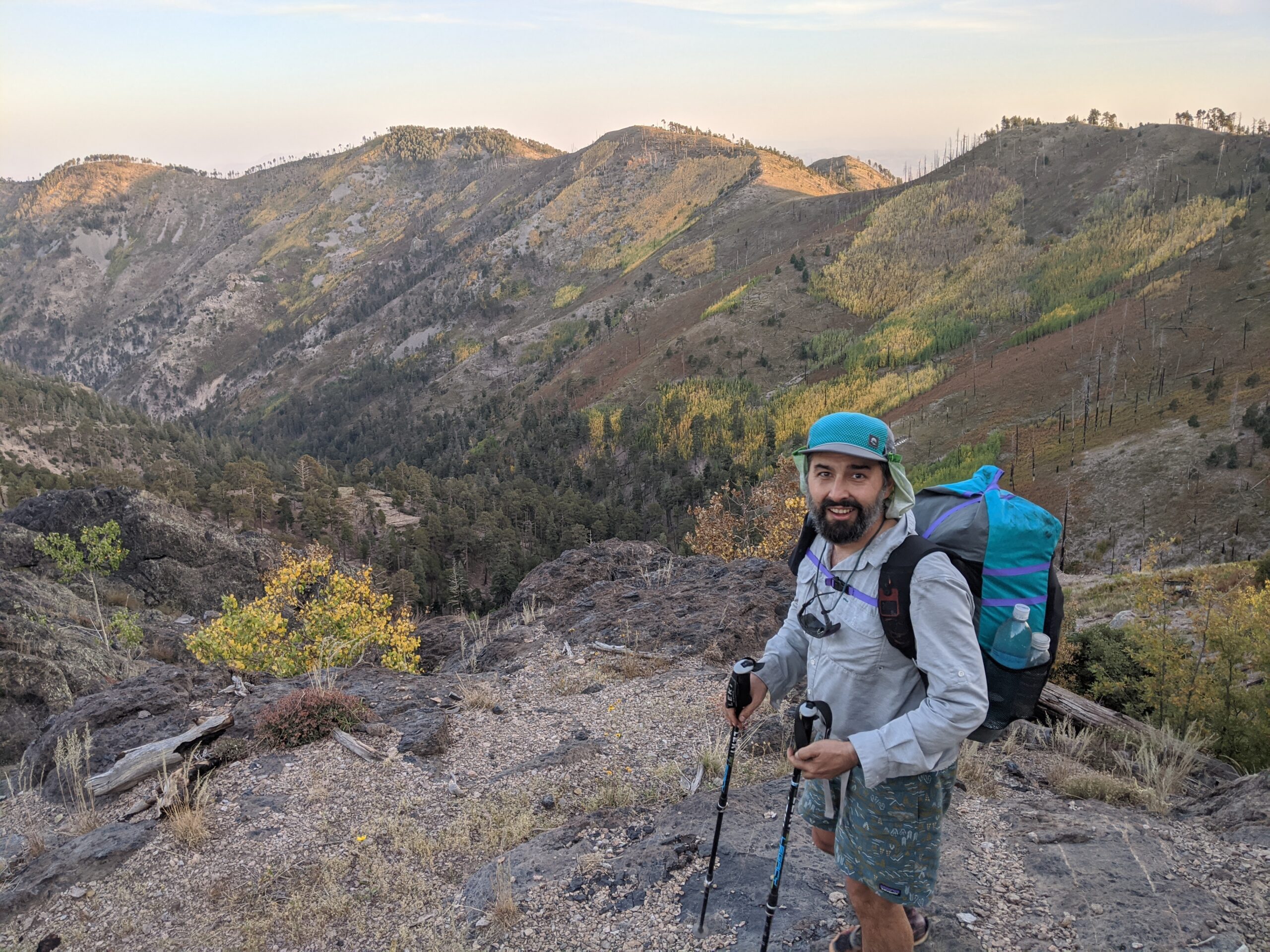
The next morning, travel was much easier. Despite being a little overgrown in some spots, the Crest Trail made for relatively easy hiking. We still managed to miss a turn somewhere and did have to do a little bit of bushwhacking to get back on track, but compared to the day before we were still cruising along at a pretty good pace. The Crest Trail follows the highest ridge of the Chiricahua range, going over Chiricahua Peak, the highest point in the range. Because there is a road and campgrounds in the area, this was the only segment of trail we saw other hikers, save those first two we saw the first day as we started out at Silver Peak and the trail maintainers at Juniper Spring. It also meant the trail was in better condition due simply to the fact that people still hike around here regularly. It was smooth sailing all the way to Onion Saddle. From there, we followed a deteriorated dirt road for a short while before joining the Jhus Horse Saddle Trail. After passing Onion Saddle, we would see no more people.

Jhus Canyon and Jhus Horse Saddle are named after the Apache leader Juh (pronounced Whoa or Who). While he is lesser known than his brother-in-law Geronimo or his friend Cochise, he was an effective Apache leader who is credited with the attack that killed Lt. Cushing. Today the area near the saddle is dotted with the remnants of mining and grazing, but few people seem to come to this side of Onion Saddle. Despite the trail maintenance from a year earlier, the trail felt abandoned and was being rapidly reclaimed by nature. The spring that would be our only water source for the day, Iron Spring, is located a ways downhill from Jhus Horse Saddle along the Pinery Horsefall trail. We followed the trail down to the spring and enjoyed a long lunch.

The day was hot, unseasonably hot, and despite our improved rate of progress, we did not know what kind of terrain was ahead of us or whether we would be able to reach the next water source before the day was over. Had we been hiking in the springtime after a decent rainy winter, much of the route we were following would have intermittent pools of water or even flowing water in some of the drainages. Alas, this was fall and the summer rains had been below average, meaning we could only count on the most reliable springs to have water. The hotter weather, slower-than-anticipated pace, and overall scarcity of water sources was starting to become a source of stress. It was exceptionally difficult to determine how much water we would need between each source. Furthermore, aside from knowing which springs were considered more reliable, we had no way to know for certain whether they were actually running, so we always had to have a backup plan in case we came upon a dry source. It was only 4 miles to the next spring, but we filled up 7 liters to carry. The filter was running very slowly due to the algae clogging from the night before, despite some frequent back flushing.

After our long break, we climbed back up to the saddle and continued northward on the Shaw Peak Trail. From there, things rapidly started to get hairy. As we came around the back side of Shaw Peak, the slope was steep and the trail was quite deteriorated.Still, we carried on, stepping carefully, stopping every now and then to find a safe route around the thorny vegetation. Eventually the trail had mostly vanished. We seemed to be following game trails or making our own path, until we found the remains of a barbed wire fence that we followed to Shaw Saddle, where we took another break at a small flat space below a juniper tree before continuing.

Once again we felt like we were following a game trail more than an actual trail, and the terrain got steeper as we contoured along the steep slope. Our progress ground to a snail’s pace. Stopping to take a break felt treacherous because the terrain was so steep and there was no flat ground to stand on. Every step felt precarious and made me wish there was something to grab onto, even if only a tree branch to steady myself. Unfortunately, the vegetation was mostly agave and cactus. If one of us slipped and fell, there would likely be a serious injury to deal with, so we moved with caution. And it was hot.
We started to realize that at the pace we were moving, we would still be on the slope until after dark. This felt way too dangerous for both of us. Additionally, in the heat we had consumed more water than we’d planned. If we turned back to the last saddle and camped for the night, we would definitely not have enough water to carry us through the next day. Either we’d have to carry on tonight, or go all the way back to Jhus Horse Saddle and down Pinery Canyon to Iron Spring to refill in order to come back and make another attempt at crossing this sketchy slope. The terrain was scary enough in full daylight, so there was no way we were going to risk being in the same position after dark. We had no choice but to turn back and regroup.

The saddle was a poor excuse for a campsite. We crammed our sleeping pad into the flattest spot we could muster and didn’t bother with setting up the tarp. It was a warm night and I slept restlessly, intimidated by the terrain and frustrated by our backward progress.
In the morning, after reviewing our options, our mental state, and our supplies, we decided to bail out so we could regroup, make some gear adjustments, and re-evaluate. We returned to Iron Spring. It took an hour to cover the 1.3 miles to get there. We refilled on water, then continued following the Pinery Horsefall trail down to the road, and onto the National Monument. Naturally, the Pinery Horsefall trail is in good shape. I wonder where the name came from. There are conflicting stories about how Juh died, but both accounts agree he fell from his horse. I wonder if this is why the saddle is called Jhus Horse Saddle, or why this trail is called the Horsefall trail. Either way, this is not the place he died. Still, it is not a stretch to imagine that he stood in this place or drank from this spring when he lived. Same goes for Cochise or Geronimo. They knew how to move through this landscape better than we do even now.

Returning home, I tried to find an account of anyone having done this particular segment of trail recently and I was unable. A brave soul could make it, but at high risk of injury, and I’m not sure it’s worth the effort. After a few days’ rest, Paul and I decided we were ready to change gears and turned our sights onto a much more approachable Sky Island range: the Rincons.
Looking back, what an odyssey we had in these mountains, and we still have half the range left to finish. I think to do so we will start from the northern end and work our way back south toward Shaw Peak. Even if that one slope still proves impassable, all of our re-routing and road-walking ultimately still provides a continuous path through the range. I am humbled at how the Apache were able to move quickly through this terrain and evade their pursuers time and time again.
4 thoughts on “Part Foolish and Part Brave in the Chiricahuas”